
Introduction to Ebulobo Volcano

Ebulobo Volcano
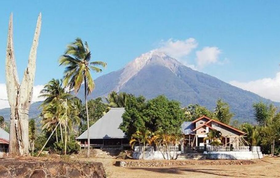
Trekking in Flores—Ebulobo Volcano, situated in the heart of Flores, Indonesia, offers one of the most rewarding mountain trekking experiences on the island. Known for its striking conical shape and dramatic volcanic landscape, Ebulobo attracts adventure seekers who wish to explore a lesser-known yet breathtaking trekking destination. The trail up this dormant stratovolcano takes hikers through lush vegetation, rocky volcanic slopes, and panoramic viewpoints that reveal Flores’ diverse natural beauty.
Despite its geological importance as part of the Pacific Ring of Fire, Ebulobo today is mostly quiet, making it an ideal destination for safe and enjoyable trekking. Rising to approximately 2,300 meters, the volcano provides a challenging but accessible climb suitable for intermediate trekkers. Its andesite-rich terrain and steep sections offer both physical excitement and stunning visual rewards, especially at sunrise when the surrounding highlands glow with warm light.
Beyond its natural allure, Ebulobo holds deep cultural significance for local communities. Myths and traditions surrounding the mountain enrich the trekking experience, allowing hikers to connect with the cultural landscape as they ascend. Guided treks often include insights from local villagers, adding a meaningful human dimension to the journey.
Trekking Ebulobo is more than just reaching the summit—it’s an immersive experience combining adventure, culture, and nature. Exploring this volcano highlights the harmonious relationship between Flores’ geological heritage and the communities who live in its shadow, making it a must-visit destination for trekking enthusiasts in Indonesia.
Understanding Description Trekking
:strip_icc():format(webp)/kly-media-production/medias/4666819/original/010727800_1701186406-WhatsApp_Image_2023-11-28_at_22.30.18.jpeg)
Description of trekking at Ebulobo Volcano in Flores refers to the process of understanding, documenting, and interpreting the various elements that shape the trekking experience—from trail characteristics and physical challenges to landscape features and cultural encounters. This descriptive approach helps trekkers prepare, appreciate the terrain, and gain deeper insight into what makes Ebulobo one of Flores’ unique trekking destinations.
One important aspect of trekking description is analyzing the trail conditions. This includes observing the changing terrain, which typically transitions from gentle village paths to steeper volcanic slopes composed of loose rocks and hardened lava. Understanding these variations allows trekkers to anticipate the physical demands of the ascent and choose appropriate gear. Describing the elevation gain, difficulty level, and duration of each segment of the route also supports better trek planning and safety.
Another key component involves documenting the natural landscapes encountered along the trail. Ebulobo’s trekking route showcases lush vegetation at the lower elevations, gradually giving way to more rugged volcanic terrain near the summit. Trekkers often note the panoramic views, geological formations, and the dramatic conical shape of the volcano. These descriptions help illustrate the visual richness of the experience and provide future trekkers with a realistic sense of what to expect.
Cultural elements also play a significant role in the trekking description. Ebulobo is closely connected to local communities whose traditions, stories, and daily life contribute to the atmosphere surrounding the trek. Including these cultural impressions—such as passing through traditional villages or learning local legends about the volcano—adds depth and meaning to the journey.
Finally, data such as weather patterns, trail markers, rest points, and safety considerations form another crucial part of trek description. Documenting these factors helps ensure that trekkers understand potential challenges, especially because mountain conditions can change rapidly. By compiling and analyzing these descriptions, adventurers can better prepare for a safe and enjoyable ascent.
Overall, understanding trekking at Ebulobo Volcano involves more than simply climbing to the summit. It is about recognizing the interplay between physical challenge, natural scenery, and local culture—elements that together create a memorable trekking experience in Flores
Significance of Ebulobo in Local Culture and Environment
Ebulobo Volcano, standing majestically in Flores, Indonesia, is not merely a geological structure; it plays an integral role in the cultural and ecological fabric of the surrounding communities. The indigenous populations regard the volcano with profound respect, imbued with numerous myths and legends that define their identity and heritage. Local beliefs often attribute spiritual significance to Ebulobo, positioning it as a sacred entity that offers protection and guidance, reflecting the close ties between the people and their environment.
The volcano’s presence significantly influences agricultural practices in the region. The fertile volcanic soil provides optimal conditions for cultivating various crops, notably maize, rice, and coffee, which are staples for the diet and economy of the local communities. As a result, many families engage in traditional farming methods that have been passed down through generations, facilitated by the rich nutrients found in the soil enriched by volcanic activity. This agricultural reliance demonstrates the dual nature of Ebulobo as both a provider and a source of life, sustaining livelihoods while fostering a deep connection to the land.
Ebulobo Volcano is also pivotal to the region’s biodiversity. Its diverse ecosystems harbor various flora and fauna, some of which are endemic to Flores. The unique microclimates created by the volcano’s varying altitudes contribute to a rich tapestry of habitats, supporting a wide range of species. These ecosystems not only play a crucial role in maintaining environmental balance but also enhance the local community’s livelihood through sustainable practices, such as eco-tourism and traditional medicine derived from local plants. Thus, the intertwined relationship between Ebulobo and the communities living in its shadows highlights the necessity of preserving this natural treasure, which is both a cultural symbol and a vital ecological asset.
Historical Eruption Activity of Ebulobo
The Ebulobo Volcano, located on the Indonesian island of Flores, has a documented history of eruptive activity that plays a crucial role in understanding its current status and the appropriate response from local communities and authorities. Ebulobo’s eruptions have significantly influenced the surrounding environment and have left behind geological evidence that is essential for volcanic study and local preparedness.
The most notable eruption of Ebulobo occurred in 2008, which resulted in a moderate explosion accompanied by ash fall affecting nearby settlements. This event mandated immediate evacuation and highlighted the need for comprehensive emergency response plans for residents living in the vicinity. In the years preceding 2008, minor eruptive phases were recorded—each providing valuable data on the volcano’s behavior and potential hazards.
Geological studies have shown that Ebulobo’s last major eruption occurred around 1941, with subsequent smaller activity leading up to the 2008 event. These eruptions have deposited layers of tephra in the surrounding area, providing a clear record of the volcano’s historical activity. The local communities have adapted to the presence of this active volcano, incorporating traditional knowledge about volcanic activity into their daily lives.
The government, in collaboration with geological experts, has established monitoring systems to track signs of volcanic unrest. These systems are crucial in anticipating potential eruptions by analyzing seismic data, gas emissions, and ground deformation. The integration of modern technology with historical knowledge significantly enhances local preparedness levels, allowing communities to respond effectively to the dynamic nature of Ebulobo Volcano.
Understanding the historical eruption activity of Ebulobo is essential for appreciating the complexities of current tracking efforts. As geological studies continue to unfold, they contribute valuable insights into the potential risks associated with living in the shadow of an active volcano. This foundation enables better planning and resilience among the populations that surround Ebulobo.
Current Monitoring Techniques Used at Ebulobo

Monitoring volcanoes is crucial for predicting eruptions and ensuring public safety, especially at Ebulobo Volcano in Flores, Indonesia. A multifaceted approach involving various monitoring techniques allows volcanologists to gather invaluable data regarding the volcano’s activity. Ground-based observations serve as a foundational method, enabling researchers to examine surface conditions and identify any visible signs of unrest. These on-site assessments often involve visual inspections, gas emissions measurements, and the collection of geological samples to gauge changes in the volcanic landscape.
In addition to ground-based observations, satellite imaging has gained prominence as an effective monitoring tool. Utilizing remote sensing technology, satellites can capture high-resolution images of Ebulobo, allowing for the analysis of thermal emissions, ground deformation, and changes in land cover. Such imaging assists in tracking volcanic eruptions from a safe distance, providing crucial data without putting researchers at risk. This method also enhances the ability to assess large-scale geological phenomena that ground observations may not capture comprehensively.
Furthermore, advanced technologies, such as seismic monitoring systems, play a pivotal role in the real-time tracking of volcanic activity. Networks of seismometers installed around Ebulobo detect minute vibrations in the ground caused by magma movement and other geological processes. This data informs scientists about potential eruption scenarios, enabling them to issue timely warnings when necessary.
Data integration from these various monitoring techniques enhances the overall understanding of Ebulobo’s volcanic behavior. The combination of ground observations, satellite imagery, and seismic measurements provides a more sophisticated framework for assessing the volcano’s condition. This comprehensive approach not only improves real-time monitoring capabilities but also contributes significantly to the safety measures in place for local communities residing in the vicinity of Ebulobo.
The Role of Research Institutions in Ebulobo Trekking
The Ebulobo Volcano, located on Flores Island in Indonesia, is closely monitored by various research institutions that play an essential role in understanding its geological dynamics. These institutions include local universities, national geological surveys, and international organizations specializing in volcanology. Their contributions extend beyond mere observation; they significantly influence research, education, and community preparedness regarding volcanic activities.
Nationally, the Indonesian Center for Volcanology and Geological Hazard Mitigation (PVMBG) serves as a key player in tracking Ebulobo’s activity. This organization is responsible for volcanic monitoring across Indonesia and collaborates with local universities to conduct detailed geological studies. Their research efforts involve comprehensive data collection on seismic activity, gas emissions, and physical changes in and around the volcano, which is crucial for predicting eruptions and understanding the volcanic system.
Furthermore, institutions like the Gadjah Mada University and the Bandung Institute of Technology are actively engaged in educational outreach, fostering a better understanding of volcanic risks among local communities. These education programs aim to equip residents with the necessary knowledge to respond effectively in case of an eruption, thereby enhancing disaster preparedness. By integrating scientific findings with public awareness campaigns, these institutions bridge the gap between research and community application.
International collaborations also enhance the monitoring of Ebulobo Volcano. Partnerships with foreign geological institutions enable the sharing of expertise and resources. Joint research projects often involve satellite imagery analysis, advanced modeling techniques, and international workshops aimed at improving eruption forecasting methods. Such cooperation is vital for a more comprehensive understanding of not only Ebulobo but also of volcanic activity in the broader region.
Through these efforts, research institutions play a pivotal role in enhancing the understanding of Ebulobo Volcano and fostering a resilient community in Flores that is well-informed about the potential hazards associated with volcanic activity.
Tourism and Ebulobo: Balancing Ecological Preservation and Visitor Experience
The Ebulobo Volcano, situated in Flores, Indonesia, serves as an exemplary case of how tourism can affect delicate ecosystems. With its unique volcanic landscape and vibrant biodiversity, Ebulobo has garnered attention from both local and international travelers. However, the increasing influx of visitors raises valid concerns about the preservation of the surrounding environment and local cultures. Ensuring a balance between attracting tourism and maintaining ecological integrity is paramount for the region.
Sustainable tourism practices are essential for protecting the local ecosystem while allowing visitors to experience the unparalleled beauty of the Ebulobo area. One significant implication of increased visitor traffic is the strain it places on natural resources, including water supply, waste management, and habitat preservation. As tourists explore the area, they can inadvertently contribute to soil erosion, littering, and disturbances to indigenous wildlife. Effective strategies for minimizing these impacts should be implemented to create a more sustainable tourism model in Ebulobo.
One approach involves the promotion of eco-friendly practices among visitors. Educational programs can raise awareness about the unique ecosystem surrounding the Ebulobo volcano, encouraging tourists to engage in responsible behavior. Establishing clear guidelines for visitors can help guide their interactions with the environment, fostering a sense of stewardship. Additionally, local authorities can introduce visitor limits during peak seasons to mitigate over-tourism, ensuring that both the environment and visitor experiences remain optimal.
Furthermore, collaborating with local communities to develop tourism initiatives will not only preserve cultural heritage but also promote economic opportunities for residents. Sustainable tourism should incorporate local traditions, crafts, and food, enriching the visitor experience while providing financial benefits to the community. In these ways, the path to sustainable tourism in the Ebulobo region can be effectively navigated, fostering an environment where both nature and culture flourish.
Future Prospects of Ebulobo Volcano Monitoring
The Ebulobo Volcano, located on the island of Flores in Indonesia, continues to be a significant subject of research and monitoring due to its potential for volcanic activity. Future prospects for enhanced monitoring of this volcano are closely linked to advancements in technology, international cooperation, and ongoing scientific research. Emerging technologies play a crucial role in providing accurate, real-time data that can improve the understanding of volcanic behavior and facilitate better decision-making.
One of the forefront technologies for monitoring volcanoes is the use of remote sensing via satellite imagery and airborne surveys. These methods allow for the continuous observation of surface deformation and thermal anomalies around Ebulobo. Additionally, implementing advanced seismic monitoring systems makes it possible to detect precursory events associated with volcanic eruptions. Such improvements are expected to enhance predictive capabilities significantly, allowing scientists to issue timely warnings and mitigate potential hazards.
International collaboration is equally vital in the quest for more effective monitoring of Ebulobo Volcano. Partnerships among various countries and institutions can lead to the sharing of data, best practices, and technological advancements, thereby enriching the global knowledge base regarding volcanology. Joint research initiatives could pool resources and expertise, facilitating comprehensive studies aimed at developing more refined descriptive tracking models for volcanic activity.
Moreover, community engagement is another essential aspect of advancing volcano monitoring endeavors. Local populations are often the first line of defense against volcanic hazards; therefore, incorporating traditional knowledge and paying attention to community observations can prove invaluable. When combined with modern approaches, this synergy can lead to enhanced resilience against potential eruptions.
As a result, the future of Ebulobo Volcano monitoring appears promising, with advancements in technology, robust international partnerships, and a greater focus on local engagement poised to revolutionize the field of volcano observation and predictive science.
Conclusion: The Importance of Continuous Description Tracking
Continuous description tracking of the Ebulobo Volcano plays a pivotal role in ensuring the safety and well-being of local communities and ecosystems. This ongoing monitoring process facilitates timely responses to volcanic activity, which can mitigate the risks posed to the residents living in proximity to the volcano. By systematically gathering and analyzing data on changes in the volcano’s behavior, scientists can better understand its eruptive patterns, thereby enhancing early warning systems that protect lives and property.
Moreover, tracking the Ebulobo Volcano contributes significantly to our scientific knowledge of volcanic activity. It allows researchers to develop more effective models predicting future eruptions and their potential impact, both regionally and globally. Such knowledge is vital not only for disaster preparedness but also for advancing our understanding of volcanology as a whole. Detailed documentation of each phase of the volcano’s life cycle enriches the academic field and may lead to innovative solutions and sustainable practices in managing volcanic landscapes.
In addition to its scientific implications, continuous description tracking also serves to preserve the cultural heritage associated with this iconic landmark. The Ebulobo Volcano is integral to the identity of the local communities, and its history enriches the collective narratives of the region. By documenting the volcano’s status and its interactions with human life, we ensure that the stories and traditions surrounding it are not forgotten. This fosters a sense of connection among residents and encourages future generations to engage with their environment actively.
In light of these points, we encourage readers to take an interest in the ongoing monitoring efforts at Ebulobo Volcano. By staying informed and engaged, individuals can contribute to the effective management of volcanic risks, support research initiatives, and honor the cultural significance of this remarkable natural monument.


